Object
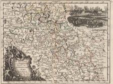
Title: Le Duche De Silesie divisé en XVII. Principautées á Paris Par et chez le S.r le Rouge Ing.r Geog. rue des Augustins Avec Priv. Du Roi 1743
Description:
[1] mapa : miedzioryt kolorowany, mapa w ramce ; 24x33,5 cm (w ramie 20x26 cm) ; Skala ok. 1 : 1 800 000. Tytuł w języku francuskim w lewym dolnym rogu w nieregularnym kartuszu, z wolutami z motywem muszlowym i roślinnym, zwieńczonym herbem Śląska w górnej części, po bokach w dolnej części kartusza putta. ; W prawym górnym rogu mapy scena oblężenia twierdzy, pod którą podziałka liniowa (8. Miles com d’Allemagne).W prawym górnym rogu na marginesie numer: 57
Publisher:
Georges Louis Le Rouge [Prault & Robinot]
Place of publication:
Format:
Resource Identifier:
Original Identifier:
Language:
Rights Management:
Wojewódzka Biblioteka Publiczna w Opolu
Object collections:
Last modified:
Nov 16, 2021
In our library since:
May 16, 2015
Number of object content hits:
12
Number of object content views in Mapa format
11
All available object's versions:
https://obc.opole.pl/publication/8022