Object
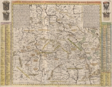
Title: Carte de Royaume de Boheme. La chronologie de ses rois. Les états de Silesie, Moravie et Lusace
Description:
[1] mapa : miedzioryt kolorowany ; 48x62 cm, arkusz 52,5x64,5 cm ; Mapa zamieszczona w atlasie Henri Abrahama Châtelaina, Atlas historique, ou nouvelle introduction a l'histoire, à la chronologie & à la géographie[...], T.2, wydanego w 1720 r. ; Między ramkami litery skorowidzu ; Pod ramką, w prawym dolnym rogu przywilej: „Avec Privilege de Nosseigneurs les Etats de Hollande et de Westfrize” ; Poza wschodnią ramką mapy na górze herby: SILESIE, LUSACE ; poniżej w kolumnach: „Chronologie des Ducs et Rois de Boheme”, „Table des Principaux Etats de cette Carte”, „TABLE DES RIVIERES LES PLUS REMARQUABLES” ; Poza zachodnią ramką mapy na górze herby: Boheme, Moravie ; poniżej wykaz miast: TABLE DES VILLES LES PLUS Remrquables ; Podzialka liniowa: Lieux d'Allemagne 15 dans un Degré 15 = [10,9 cm] ; W prawym górnym rogu planszy „Tome 2 N.o 39” ; W górnym lewym i prawym rogu mapy teksty historyczne „Remarque” po 32 i 36 wierszy
Publisher:
Place of publication:
Resource Identifier:
Original Identifier:
Language:
Rights Management:
Wojewódzka Biblioteka Publiczna w Opolu
Object collections:
Last modified:
Jan 24, 2023
In our library since:
Jan 24, 2023
Number of object content hits:
42
Number of object content views in Mapa format
0
All available object's versions:
https://obc.opole.pl/publication/20188