Object
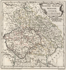
Title: Bohême Silésie, Moravie, Lusace
Description:
[1] mapa : miedzioryt kolorowany liniowo ; 26,5x26 cm, arkusz 29x35,5 cm ; 2 podzialki liniowe pod kartuszem ; Echelle: 2 podziałki liniowe: Mille pas géom? de 60 au degré 50 = [4 cm], Milles d'Allemagne de 15 au deg? 10 = [3,3 cm] ; W prawym górnym rogu, poza odciskiem matrycy, ręczny numer „26” ; Pod dolną ramką z lewej adres wydawniczy, z prawej Gravé par E. Dussy ; Tytuł w kartuszu w prawym górnym rogu mapy ; Verso: w prawym górnym rogu ręczny napis: Boheme, Silesie, Moravie, Lusace; obok numer mapy „26”
Publisher:
chés l'Auteur, Quai de l'Horloge près le Pont neuf
Place of publication:
Contributor:
Resource Identifier:
Original Identifier:
Language:
Rights Management:
Wojewódzka Biblioteka Publiczna w Opolu
Object collections:
Last modified:
Jan 25, 2023
In our library since:
Jan 25, 2023
Number of object content hits:
0
Number of object content views in Mapa format
0
All available object's versions:
https://obc.opole.pl/publication/20261
Show description in RDF format:
Show description in OAI-PMH format:
| Edition name | Date |
|---|---|
| 532k zab, Bohême Silésie, Moravie, Lusace / Par le S. Robert de Vaugondy | Jan 25, 2023 |