Object
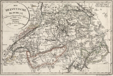
Title: Die Helvetische Republik Nach ihrer neuesten geographischen Verfassung im Jahre 1802
Description:
[1] mapa : miedzioryt kolorowany ręcznie (granice administracyjne) ; 26x37 cm, mapa w ramce 21x32 cm ; Skala ok. 1 : 1 200 000. Tytuł w lewym górnym rogu w prostym kartuszu w formie okręgu ; W prawym górnym rogu 2 podziałki liniowe (Geographische Meilen: 15=1 Gr.d.B. : 6 mil – 3,7 cm – cm), (Kl.Schweitzer Meilen 12 = 1 Gr.d.B). Mapa załącznikowa, pod dolną ramką z prawej strony napis: Fur d.A.G.Ephem. Bd.X.St.4
Publisher:
Im Verlage des Land: Industrie Compt.
Place of publication:
Format:
Resource Identifier:
Original Identifier:
Language:
Rights Management:
Wojewódzka Biblioteka Publiczna w Opolu
Object collections:
Last modified:
Nov 15, 2021
In our library since:
Apr 29, 2015
Number of object content hits:
9
Number of object content views in Mapa format
6
All available object's versions:
https://obc.opole.pl/publication/7977
Show description in RDF format:
Show description in OAI-PMH format:
| Edition name | Date |
|---|---|
| 150k, DIE HELVETISCHE REPUBLIK Nach ihrer neuesten geographischen Verfassung im Jahre 1802 | Nov 15, 2021 |