Object
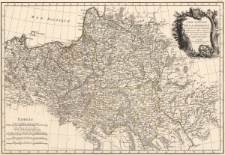
Title: Carte generale de la Pologne : avec tous les Etats qui en dependent
Description:
[1] mapa : miedzioryt kolorowany liniowo ; 30x44,5 cm, arkusz 39x51 cm ; Cytata bibliograficzna: Mojski, Cartographia Rappersviliana Polonorum, strona 200 ; Echelle [około 1:4 100 000], 5 podziałek liniowych: Lieues de Pologne de 28. au Degré, 84 = [8,2 cm] ; Nad górną ramką z prawej strony: N° 19 ; Pochodzenie mapy: Atlas moderne ou collection de cartes sur toutes les parties du globe terrestre, Paris 1771 Lattre et Delain ; Tytuł w prawym górnym rogu w rokokowym kartuszu zwieńczonym tarczą herbową z orłem na czarnym tle, u dołu druga tarcza herbowa z orłem ; Verso: blanco
Publisher:
Place of publication:
Resource Identifier:
Original Identifier:
Language:
Rights Management:
Wojewódzka Biblioteka Publiczna w Opolu
Object collections:
Last modified:
Feb 3, 2023
In our library since:
Feb 3, 2023
Number of object content hits:
0
Number of object content views in Mapa format
0
All available object's versions:
https://obc.opole.pl/publication/20273