Object
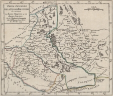
Title: Partie orientale de La Russie Polonoise : ou se trouvent La Basse Volhynie et La Basse Podolie
Description:
[1] mapa : miedzioryt kolorowany liniowo ; 17,5x20 cm, arkusz 20x22,5 cm ; Cytata bibliograficzna: Baza IKAR ; Echelle 1:3 500 000, podziałka liniowa: Lieues d'une heure, 20 = [3,3 cm] ; Między ramkami opisano strony świata: septentrion, midi, occident, orient ; Nad górną ramką w prawym rogu nr mapy: 122 ; Pochodzenie mapy: Atlas portatif, universel composé d'apres les meilleures cartes, tant gravées que manuscrites des plus célébres géographes et ingénieurs / par Robert de Vaugondy. Paris : Dépôt de Géographie, [ok. 1774] ; Pod tytułem i adresem wydawniczym przywilej: Avec Privilege ; Podziałka liniowa w prawym górnym rogu mapy ; Południk zerowy [Ferro] ; Rzeźba terenu: kopczyki ; Tytuł mapy w lewym górnym rogu ; Verso: blanco
Publisher:
Place of publication:
Resource Identifier:
Original Identifier:
Language:
Rights Management:
Wojewódzka Biblioteka Publiczna w Opolu
Object collections:
Last modified:
Jan 25, 2023
In our library since:
Jan 25, 2023
Number of object content hits:
20
Number of object content views in Mapa format
0
All available object's versions:
https://obc.opole.pl/publication/20262


